MY WORK
editing / filmmaking
gossweiler ingenieuere ag
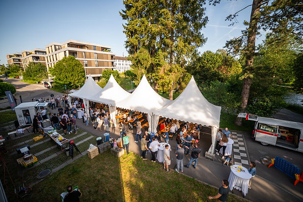
24 hours at HUBER+SUHNER. Directed, produced and edited by Robin Rohner & Mischa Bauckhage.
In addition to my job as a geomatic engineer at Gossweiler Ingenieuere AG, I was able to record several events for the company in a video.

mobility
Mobility – Auto Reinigen. Directed, produced and edited by Mischa Bauckhage.
I've had the privilege of working with Mobility for over a year now, producing videos for social media and Mobility Neo magazine.

huber+suhner
24 hours at HUBER+SUHNER. Directed, produced and edited by Robin Rohner & Mischa Bauckhage.
The great cooperation with Huber+Suhner has already lasted more than five years. At the end of 2022, we completed our largest project to date for our long-standing client.
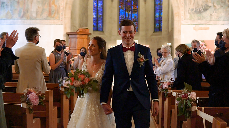
weddings
I filmed two beautiful weddings yet, those of Pinia & Mauro Cadonau, as well as Sina & Jlian van Krimpen.
Mobility – Auto Reinigen. Directed, produced and edited by Mischa Bauckhage.
Pinia & Mauro | Wedding. Filmed and edited by Mischa Bauckhage.

nature
On all my journeys I have my camera with me to capture the nature and adventures.
SHOWREEL. Directed, produced and edited by Mischa Bauckhage.

climbing
Me and my friends love to go climbing in the mountains. Videos were created from some of our trips.
Altenalptürme | 2020. Filmed and edited by Mischa Bauckhage.

cars
Small project showing a beautiful Pontiac Firebird.
Pontiac Firebird. Filmed and edited by Mischa Bauckhage.
photography

switzerland
I love to travel around my home country and discover all the beautiful landscapes and mountains.

new zealand
I traveled one month through the land of breathtaking landscapes and untamed wilderness, exploring New Zealand’s majestic mountains, pristine lakes, and rugged coastlines.

tanzania
Two weeks of safari through the national parks of Tanzania.
some impressions (in progress)

iceland
In the summer of 2024, I traveled for three weeks through the land of fire and ice, exploring Iceland’s dramatic landscapes. I witnessed some of the most breathtaking sights, from towering waterfalls to vast glaciers, all illuminated by the endless golden glow of the midnight sun.

italy
Multiple trips to italy, especially to the dolomites.
some impressions (in progress)

norway
In summer 2019 I travelled for three weeks through the land of endless fjords and experienced some of the most beautiful and never ending sunsets of the midnight sun.


study projects
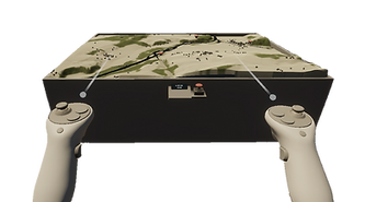
Modelling Historical River Landscape Evolution in Virtual Reality
Geomatics Master Project | Autumn Semester 2024
This project explores the visualization of temporal river landscape evolution through 3D techniques in a Virtual Reality setup. Historical topographic maps are used as the data basis to create digital elevation models and textures. Using Unity and the High- Definition Render Pipeline, photorealistic landscapes are generated and integrated into an immersive VR environment. The workflow is designed to be automated and reproducible, with potential applicability to other historical maps. The resulting interactive VR application allows users to interactively explore the historical evolution of river landscapes, focusing on a study site in Laupen BE, Switzerland. While the workflow automates many steps, some manual preprocessing remains necessary.
Building a Planning Tool for the E-Bike City
Geomatics Master Project | Spring Semester 2024
This project focuses on the development of a user-friendly web application to support urban planners in optimizing road networks for micromobility, particularly cycling. It is part of ETH Zurich’s ”E-Bike City” project, which aims to rededicate urban street space to pedestrians, cyclists and e-bikers in order to combat climate change and promote public health. The web application aims to visualize and analyze op- timized bike and car networks, facilitating decision-making in urban planning. Key components include a novel optimization algorithm balancing the needs of cyclists and car users, as well as a user interface allowing for intuitive control and comparison of network configurations. The resulting tool serves as a bridge between research and practice, empowering planners to integrate sustainable transportation solutions into real-world applications. The resulting website can be accessed here.

geoTour – hiking portal (v1.0)
Application Development in Cartography | Autumn Semester 2023
The main purpose of geoTour is to provide a comprehensive platform for hiking enthusiasts in Switzerland. It aims to offer a 3-dimensional preview of hiking routes, enabling users to assess the terrain, elevation, and difficulty of each hike. Existing hiking portals often lack 3-dimensional preview, making it challenging for users to assess the terrain and difficulty of hikes. geoTour aims to solve this problem by offering detailed visualizations and critical information for each hiking route. The website can be accessed here.

mARio Party
GIS and Geoinformation Lab | Autumn Semester 2023
The "mARio pARty" project at ETH Zurich's GIS and Geoinformations Lab integrates location-based technologies with Augmented Reality (AR) to create an immersive indoor game for the Microsoft HoloLens 2. Inspired by "Mario Party," the game unfolds across three themed levels on the HIL building's floor at ETH Hönggerberg. Players navigate using a physical map augmented with digital information, rolling a dice to progress and facing challenges that test their knowledge of the Mario world.
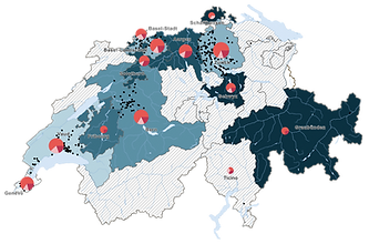
Veränderung der Verkehrsmittelwahl durch Covid-19
Projekt GIS & Kartografie | Spring Semester 2022
Mit dieser Arbeit wird das Verhalten der Schweizer Bevölkerung bezüglich Verkehrsmittelwahl vor und während der Covid-19 Pandemie untersucht. Aus der Analyse, welche auf den Bewegungsdaten der MOBIS-Studie basiert, geht hervor, dass nur ein marginaler Rückgang der ÖV-Nutzung während des Lockdowns zu verzeichnen ist. Die Veränderungen fanden grösstenteils als Wechsel zwischen NMIV und MIV statt. Diese Resultate wurden auf einer thematischen Karte der Schweiz visualisiert.
Anwendung und Beurteilung der vektorbasierten Grafiksoftware «Affinity Designer» zur Kartenerstellung
Bachelor-Thesis | Spring Semester 2022
Die Studie untersucht die Eignung von Affinity Designer als Alternative zu Adobe Illustrator für die digitale Kartenerstellung. Durch die Analyse von Kartenobjekten des Schweizer Weltatlas wird gezeigt, dass Affinity Designer grundsätzlich für die Kartengestaltung verwendet werden kann. Allerdings werden einige fehlende Funktionen identifiziert, insbesondere die fehlende Überdruckvorschau, die den Arbeitsfluss beeinträchtigen. Trotz dieser Einschränkungen wird darauf hingewiesen, dass Affinity Designer Potenzial für die Zukunft hat, da kontinuierliche Software-Updates neue Funktionen hinzufügen können.


personal projects
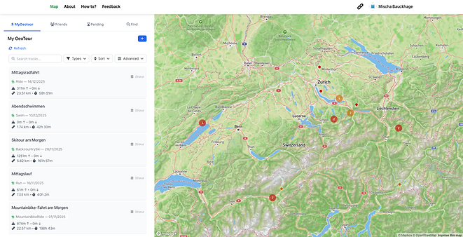
geotour (v2.0)
Online portal for registering, linking, and sharing outdoor activities.
With this project, I am trying to realize various ideas I have, as well as my passion for outdoor activities and my interest in web GIS technologies and development. Unfortunately, I rarely get the chance to continue developing it. Nevertheless, I hope to one day complete my vision of a geo-portal that can be used to create bucketlists, display strava activities, analyze climbed peaks, and share tours with other users.
The website is powered by a Python-based backend connected to a PostgreSQL database. The frontend is built with Vue.js, and the application is deployed on a Linux server.
DIY Camper Build
We have fulfilled a long-standing wish to have our own camper. However, the wish has not yet been completely fulfilled, as the vehicle is still empty and first needs to be converted into a camper. This project allows me to tackle completely new and previously unknown topics such as working with wood and electronics and general craftsmanship, which is a great change from my everyday work in front of the computer (although that's also a lot of fun too :)).


